Sunday, November 12, 2017

Oct 26 Cordova MFPC, Spain


 It was cold the morning we left Grenada for Cordova.  Ann and George are  bundled up in the first image near a place we stopped for a bathroom and Coke break. The place sold olive oil retail. There was also an Israeli guy there selling figs and nuts in packages with kosher markings. It was for a very low price too.

By the time we got to Cordova it had warmed up a lot. In the second image George is standing near the Roman bridge that crosses the Guadalquivir (the same river that flows through Seville which is a bit to the west of Cordova). The Guadalquivir River was called the Kartuba by the Carthaginian Hamilcar Barca in the 3rd century BCE. Its present name comes from the arabic al wadi al kabir (meaning 'great valley').


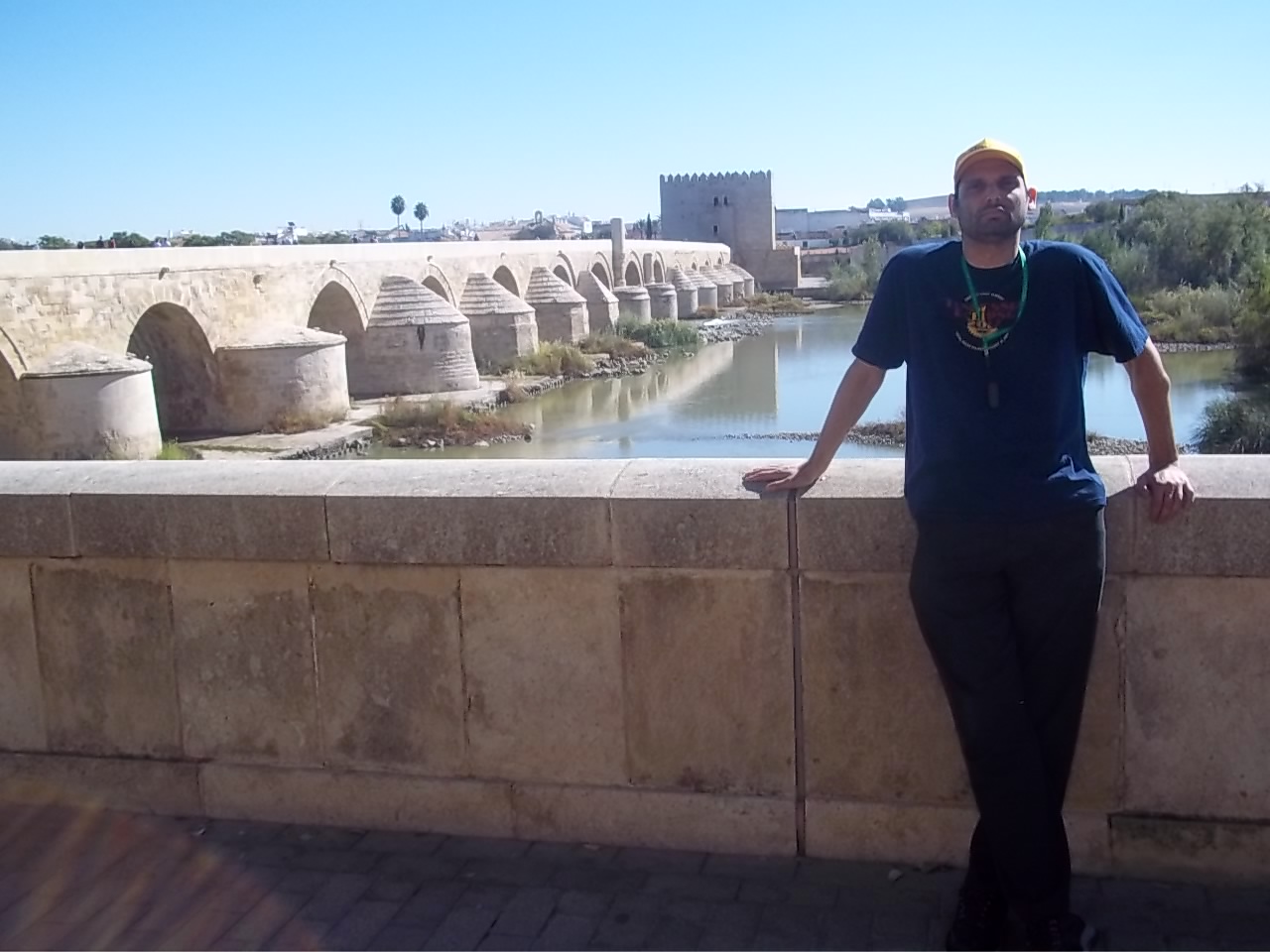
In the third image Beth is near this bridge. I really liked this bridge. It also reminds me of the Arlington VA Memorial Bridge - an image of that is here. The Romans built a bridge in the 1st century BCE and the Moors extensively reconstructed it in the 8th century. The side buttresses protecting the arch bases are a Moorish addition and probably all of them had, at one time the conical top. The bridge is about 30 feet wide.


The fourth image is the entrance to the Mosque - Fortress - Palace- Cathedral (MFPC). It is through a Roman structure. Ann is in the front. This led to a marketplace during the Roman and Visigoth eras. The Roman entrance is dedicated to Janus who represents the beginning and ending of things, which is why Janus frequently is shown twice with different expressions in art.


Some other people have nice posts up about this complex which include nice narrative. One such, with better images than mine is here or here or here.  I'll use some of writzofpassage or reginamag.com or noparticularplacetogo.net images (some of theirs are better than wikipedia's or the tourism promotion sites) later in this post. However this fifth image is mine and shows the entrance to the fortress which is the outside of the MFPC complex. 


The sixth image is also mine because for some reason I couldn't find anything like it on the internet. It shows the floor of the 6th century Visigoth church (to St Vincent the Martyr) which was constructed over by the Mosque of Cordova in the 10th century. 

After the Visigoth era, a mosque was built in the eight century and expanded several times, the last at the end of the 10th century. Beginning in the 12th century, parts of it became Christian shrines.  Major restoration work has been going on since the 19th century.  Based on what diagrams I've seen, I estimate that about 40% of the mosque has been converted to Cathedral or other Christian uses.

The seventh one is mine also for the same reason as the 6th. It shows the depth of the mosque part of the complex and also shows exhibits of some archeological finds. These include memorial stone plaques dating from the Roman and Visigoth eras. These were part of the Roman and later Visigoth marketplace that is directly under this corridor. This marketplace is much bigger than the Roman marketplace below the Seville MFPC. 


One of the most photographed rooms in Spain is the candy striped horseshoe arch part of the Mosque. The eighth image is from Reginamag. It also shows the difference between the columns many of which came from various Roman structures.  

There are over 800 columns in this structure. This ninth image from noparticularplacetogo.net shows a number of sets of column. Multiply this by about 50 to get a sense of the scale. Also, this image nicely shows the way a double arch is used to support a higher ceiling.

Inside the Mosque various Cathedral spaces were built. This tenth image is from writzofpassage.com. I thought his picture showed the scale better than others as you can see the candy striped arches on the bottom left and the soaring vault of the Cathedral in the middle.


Just a few feet from this Cathedral is the Mitrab which is a Moslem prayer niche which, if you face it, you face Mecca. This, the eleventh image is from noparticularplacetogo.net. It shows the central horseshoe arch with various versions of the scalloped arch around it.  This was one of the first places to be restored in the modern era in about 1815.

Another view of this, by reginamag.com shows in the 12th image that what appears symmetrical when looked at from one perspective seems to be a riot of asymmetry when looked at from another perspective. 


Of course a palace wouldn't be a palace without some gardens and courtyards. This 13th image from reginamag show a cobblestone orange tree courtyard (patio de los naranjos). 


Another view of this courtyard (it has about 90 orange trees) is from artencordova.com.  It is the 15th image in this post. Similar to Granada, the plantings are generally in the past few centuries but based on records and traditions. The existing orange trees look to be less than 30 years old to me but based on evidence, this courtyard probably looks the same as it did many years ago in the early Muslim period.


Similar courtyards are in less important spaces (e.g. Aracena which is in at the end of the Oct 30 post on that town). They are presumably inspired by this one.

Here, in our 16th image, is Beth in the courtyard of the orange trees.  The building on one side has a long, long line of horseshoe arches and I got the bell tower in the background. The bell tower was originally a Muslim minaret. An outer shell covered it and a bell tower was added in the 16th century.


Oct 26 Cordova, Spain old town

After leaving the Mosque-Cathedral (or MFPC) we headed to the old town of Cordova. The first image shows some of our group in the street, which while narrow, has lots of retail.


The second image shows our group going through a gate. On the other side of the gate is Maimonides Square.


The third image shows that you can see part of the Cathedral complex from Maimonides Square looking through the narrow street.You can also see the arch from the previous image.


The fourth image shows a sign that says "JUDAERIA" which means the place of the Jews (or the Jewish Quarter). Of course the sign is referring to a long ago time. The history of Cordova is complex as is the history of Jews in Cordova.  

In 1000 CE the population of Cordova was about 500,000 and it was one of the most important, cultured and wealthy cities in the world. By 1750, the population was about 20,000 and the city was poor. 

Jews had several periods in which they prospered for example, in the 10th century under Moslem rule and in most of the 14th century under Christian rule (the 10 century being the more prosperous of the two).  In both periods the Jews lived in this same area of town. In the 10th probably by choice, in the 14th by order of the King. Both periods ended with massacres, the one at the end of the 14th (1391) was the worse massacre.

The fifth image shows Ann and Beth with the hotel Maimonides in left background. The sign on the wall says, "Plaza Maimonides".


In the sixth image George is in front of another part of the Maimonides square.  Note that the center of the plaza has a six pointed star. This is a relatively (past 20 years or so) new addition.


The seventh image shows some of our group in the synagogue of Cordova. It is called the Maimonides Synagogue sometimes but it was built in the early 14th century, about a hundred years after Maimonides left Cordova* and during the relatively tolerant Christian rule (which as noted before ended with a massacre). We had a mincha minyan here, although there was no Torah scroll in the ark. This synagogue is one of the best preserved in all of Europe from that period.


The eighth image is the four of us near a statue of Maimonides.  The statue is a bit misleading because Maimonides left Cordova when he was about 11 years old. Our local guide told us that it has become very fashionable to live near the Maimonides statue and this has, consequently, distorted the real estate market.

*We don't know for sure when Maimonides left Cordova but it was about 1148. It was about the same time that the Muslim philosopher Averroes, a.k.a. Ibn Rushd, left Cordova and for the same reason. The reason was the fanatical Islamic rule of of the Almohades who persecuted Jews as well as Muslims who studied philosophy. Both Averroes and Maimonides were followers of Aristotle and both went to Marrakesh in Morocco and lived near each other there for a few years but we have no record of them meeting one another.


Malaga Spain Oct 27 - on the way to Gibraltar

 We left Cordova in the morning and were on the way to Gibraltar.

We stopped at Malaga. The first image shows the remains of a Roman fortifications below which is a restored Roman amphitheater (one of our tour group is in the image).  

Malaga is one of the oldest cities in Spain, having been a Phoenician colony. The name of the city may come from the Phoenician word for salt, mlh, which is also a Hebrew (in Hebrew pronounced melach) and Arabic term for salt. After the Phoenician period it became a Carthaginian province, then a Roman province, etc.  It is one of the biggest cities in Spain and has a nice seaport as well.


The second image is from wikipedia. The image was taken from the 14th century Moorish (emirate of Granada) fort on the 400' hill overlooking the city. This hill is called the Gibralfaro (from a Phoenician phrase, jbol faro, meaning 'Rock of Light)'. I didn't climb the hill as it would have taken too long.

We had a picnic lunch at the linear park on the left of that image. We also spoke to a guy from Texas who had decided to reside in this city. The fortress was not taken by force during the Christian re-conquest but it was surrendered by the Moslems when they ran out of food in 1487.


The third image, at the perimeter of the linear park, shows Beth and me at a statute of Solomon Ibn Gabirol an 11th century poet and neo Platonist philosopher. His philosophical work, 'Source of Life', a.k.a., Fons Vitea, developed the implications of the premise that all sub-luminary things, including the souls of humans, are made of form* and matter. The original arabic version was lost and a latin translation was, for 6 centuries, thought to be the work of someone else. 

The other famous people born in Malaga are Pablo Picasso (20th century artist) and Antonio Banderas (20-21st century actor). Malaga was also the point of several historic battles, including a sea battle during the War of Spanish Succession in 1704 and in 1937 the Battle of Malaga won by the forces of Francisco Franco.


The last image shows, in the foreground, the little park we had lunch in and the background, part of the Gibralfaro hill.

 * 'form' in classical philosophy is not what we think of form now; in that philosophy 'form' is an animating force which makes matter take both shape and function

Gibraltar Oct 28

We arrived at Gibraltar on Oct 27, stayed all day on Oct 28 (which was the Sabbath) and left the morning of Oct 29. I didn't take many pictures (Beth took some on the afternoon of the 27th).

The first image is what the Rock of Gibraltar (about 1400' at the peak) looks like as you approach it. The approach is through a Spanish passport point then to the British passport point then over a bridge and across the airfield to the city at the base of the mountain. 


The second image show me with a monkey (I'm the one with the hat). This was taken by Beth on the 27th just before we checked into the hotel.

Gibraltar has the only wild monkey colony in Europe. The monkeys probably were brought with the Moorish conquest in the 8th century (Gibraltar is named for 'Mountain of Tariq or Jebal Tariq, as Tariq ibn Zarid was the commander of the force that captured this island in 711). 

Gibraltar was conquered by Christian forces in 1464 after about two hundred years in which possession went back and forth between Moslem and Christian Kings. England gained possession of it in 1704 as part of the War of the Spanish Succession  (3rd image from wikipedia). The top of the image is the NW- the monkey colony is on the left side of the middle mountain about a third up the side). 

From the southern point of Gibraltar, the coast of Africa is visible on most days. However, as you can see on the map (from Vidiani.com), Gibraltar is not the southernmost point of Spain.

Gibraltar has one of the mildest climates in Europe with the mean temperature in the 50s in winter and the 70s in the summer. This is mostly because the Atlantic current that flows into the Mediterranean through the strait of Gibraltar all year around is about 60F all year around. 
 
The next image is of a street near the border with Spain that has a statue of Queen Victoria. This was taken on the 29th by me.


The penultimate image (not counting the map) is of our group as we go back through passport control in Spain as we left Gibraltar on the 29th. We had to take our stuff off the bus to do this since the Spanish won't come on a bus for some reason (I think it is just to intentionally annoy people). 

A brief note on the early 18th century:  As noted above, Great Britain took wartime possession of Gibraltar in 1704.  In this war, England, the Netherlands and the Holy Roman Empire were on one side with a Spanish faction. On the other side was a Spanish faction and France (see map which is from wikipedia). The 1713 Treaty of Ultrect formally ended hostilities in this war.  One clause in the 1713 Treaty forbade the residence of Jews and Moors in the town of Gibraltar. Between 1704 and 1713 Jews and Moors had come to Gibraltar. In 1727, Spain declared that Britain had abrogated the treaty (for a lot of reasons, not just the Jewish residences) and laid siege to Gibraltar. The siege failed. In 1729 Britain signed a commercial treaty with Morocco expressly allowing all the Sultan's subjects (including Jews and Muslims) to reside in Gibraltar.  There was no amended Treaty of Ultrect as the Spanish had declared it abrogated.

From the President of one of the local synagogues we heard two stories about the 1713-1727 period. I have not been able to confirm either of them. 

In one story, the Spanish became aware of Jewish residence on Gibraltar when a Spanish bishop was visiting Gibraltar and inquired as to why people were dressed up. Per the story, the bishop was told that because it was Saturday, the Jews were dressed up for Sabbath (apparently, in this story, the Moors were not noticed by the bishop) and subsequently the bishop told his government which complained to the British crown. 

In the other story, subsequent to the Spanish complaint, the British foreign office wrote to the Governor of Gibraltar requiring him to expel the Jews. 

Subsequently to that, the Governor had the Jews board a boat which sailed into the harbor and the Governor then wrote to the foreign office that he had, per requirement, expelled the Jews. The ship then sailed back to Gibraltar (the image shows the harbor in the late 1800s after the British had built a long fortified pier from the harbor - the last image is from gibraltar-intro.blogspot.com). The fortified pier in the image no longer exists.

Ronda, Spain Oct 29

 We left Gibraltar and went up the mountains to the west and north and came to a city called Ronda. This city is at about 2500'. It was founded by Celts. By the time the Romans held the city it was called  Arunda, meaning 'surrounded [by hills]'.

The first image shows our group walking down a narrow street in the city.

The second image shows George and Ann who have reached the main pedestrian and shopping center of the city.


The third image shows George in front of the Bull fighting arena. Ronda is famous for having bull fights and also school that train bull fighters. 


The fourth image (from wikipedia entry on Ronda) shows the 'New Bridge' (Puenta Nuevo in Spanish) which spans the El Tajo  canyon carved by the Guadalevin River. 

In the book, "For Whom the Bell Tolls" by Ernest Hemingway, there is a scene in chapter 10 in which there is an execution (it is set during the civil war of Spain in 1936) of civilians who were sympathizers of the losing side of a battle. 

The scene takes place on a bridge that resembles the Puenta Neuvo.  Hemingway lived here during part of the Civil War.

The last image is of George, Ann and Beth near the top of the bridge. 

From the top of the bridge to the river at this point is about 400'. The new bridge isn't that new. It was built over about a 40 year period in the last half of the 18th century.  A bridge with only one arch was built immediately before the new bridge but it collapsed.  The chamber above the middle arch was used for a prison in some periods. 


Seville Oct 29 - to the MFPC

Seville is thought to be named after the Phoenician word for lowlands, Spal.  It is a low elevation city in the southwest of Spain surrounded by hills and it gets very hot in the summer (it is one of Europe's hottest cities). The average max temperature for July is over 100F and the average min temperature in January is in the low 40sF).

The first image (which show our local guide briefing our group - Beth is in the image) is of the Golden Tower (Torre del Oro). It is called that because when first built under the Almohades, the mortar which was mixed with straw, had a golden gleam in it. It was heavily damaged by the earthquake in 1755. The tower was rebuilt in 1760 but damaged during and after the 1868 revolution. Several restorations have occurred since, most recently in 2005.

The second image is the Silver Tower (Torre de la Plata) which was also built during the Almohad era. It gleamed silver because of (I think) the large amount of quartz mixed in the mortar (I don't remember what the local guide said and couldn't find the answer on line). It survived the 1755 earthquake but was abandoned for many years until being cleaned up and restored in the early 21st century.


The third image (found on wikipedia) is a 19th century painting of what the artist imagined Seville would have looked like in the 13th century before the Mosque was built (the artist is David Roberts). It shows the golden tower (but not the silver tower) and the Guadalquivir River (which flows through Seville - its name, as noted in the discussion in a Cordova post, comes from the arabic 'al kabir' meaning 'the great valley').


The fourth image is from the other side of yet another Almohad tower (I don't remember its name and couldn't find it on line). 

The image shows how commercial structures have been integrated into the complex including the medieval structures.


The fifth image shows George and other members of our group on the commercial side of the street opposite the Mosque-fortress-Palace-Cathedral (hence MFPC). 


The sixth image shows our group (Ann in foreground) getting a briefing before going into the Seville MFPC.  


A Roman viaduct (which once delivered water from the hills and which somehow survived the 1755 earthquake) from that period is in the background.  The Roman structures were reinforced during the Almohad era.


It is not obvious to me why a viaduct was built to carry water to a city which is built on a river (nor was I able to discover an answer on line). 

Perhaps, back then the river dried up in the summer enough that the Romans wanted a back up water supply. Or perhaps the river was contaminated in the summer.


The MFPC of Seville, Spain Oct 29


The complex containing the Seville Mosque, Fortress, Palace, Cathedral (hence MFPC), sometimes called the Alcazar which comes from the arabic word 'alqasr' meaning 'Royal House' seems to be spread over about (by my estimate) 20 acres (I couldn't find an exact figure online). It covers a triangular section of Seville. It is the oldest palace in the world still occupied by a King. The Spanish King sometimes resides in the palace (mainly in the winter since Seville averages a max of above 60F even in January).

The Seville MFPC is built on the site that was once a Roman Market square and near it a Visigothic Church. It was a fortress and mosque under the first moorish kings, then became a palace and larger mosque under later Almohad rulers, then partially converted into a bigger palace by the Castillian Kings who reconquered Seville in the 14th century with a Cathedral over the outer Mosque buildings. Other changes were made thereafter. This differs from the Cordova situation where the various parts of the interior of the mosque was changed into a Cathedral. The Seville complex also has a small church (without an officiate by the bishop) so it could have been called a MFPCC (last C for church). Our local guide said that the church is getting better attendance than the Cathedral lately because the Archbishop has instituted a Sunday Mass in the Cathedral that lasts over 2 hours long or maybe it was two hours longer than the Mass in the church  (I had to hold myself in to keep from LOL).


Some of the images below are mine. Others are from wikipedia or seville-traveller.com, Sevillaonline.es or similar sites.

My first image is of George in front of the main entrance to the MFPC.  This structure was constructed under Peter (Pedro) I (aka, Pedro the Cruel). It uses a variety of artistic styles from the moorish (the two surface arabesques arches beside the opening) to neo-classical (the plain arches on the ground level) and other styles.

My second image shows Ann walking along a long mosaic wall. There must be a hundred different mosaic walls, doorways, etc. in this complex.  The lane that Ann is walking in lies over the center of the Roman marketplace which was covered over by the Mosque fortress.


My third image shows us in the complex where there are a lot of marble columns. The columns are different. It indicates that the mosque builders had a pre-existing supply of columns probably from different parts of the Roman marketplace or the Visigoth Church.

My fourth image shows the Cathedral part of the complex. The enormous Christian bell tower was made by converting a Minaret for the Muezzin (Muslim prayer tower). A member of our group is at the bottom of the image. 


My fifth image is of George in front of one of the baobab trees (which are native to the edges of the grasslands of Africa) in one of the gardens on the outside of the complex. These are possibly the furthest pole-ward a baobab tree grows (there were actually about a half a dozen of these). Seville is at 37N, about the same latitude as Richmond, VA but with a much warmer climate. 

My sixth image is of George in front of recently built (2014) monument to Columbus which is in the Garden of Murillo just outside the MFPC complex.  Columbus, during his decade long negotiation undoubtedly did some of this in Seville (there is more about Columbus in a separate post on this blog).


One of the places in the complex that we visited was the Courtyard of the Maidens (Patio de las doncellas). My picture wasn't nearly as nice as this one from Wikipedia. This courtyard has been used in movies, e.g., the Kingdom of Heaven. The name of the courtyard is based on the legend that the Moslems required tribute of 100 Christian maidens each year (in some years, maidens were  'purchased' by the Emir at prices dictated by Royal decree, but the 100/yr figure is a gross exaggeration).  One of the interesting architectural aspects of this courtyard is that the upper story (which was a 16th century addition) is done in an Italian Renaissance style (Roman arches in sequence with conscious symmetry) while the bottom (14th century) is clearly Moorish (arabesque pointed arch with double columns).
Another place we went was the Ambassador's room (image from Sevillaonline), in Spanish, the Salon de los Embajadores. The entrance is famously called the horseshoe arch (Arcos de Herradura). The room is completely tiled.

The next image (from theworldinlight.com) is of an interior entrance which includes intricate tiling and Moorish arches. 
 
In the bottom right is a design made up of six pointed stars (you have to click on the image  to see this). The six pointed star has been used since ancient times (at least as early as the 3rd century) but not just as a Jewish symbol (the use of the 6 pointed star identified as the shield of David only became common in Judaism in the 19th century). Morocco had a 6 pointed star on their national flag as late as 1915.